


115 bridges, 63 tunnels...and that's just Mazatlán to Durango!
History of Federal Highway 40 / 40D
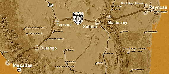
Mazatlan to Texas on Highway 40 / 40D
Federal Highway 40 begins at Reynosa, Tamaulipas State -- just south of McAllen, located at the southern tip of Texas -- and ends in Villa Union, Sinaloa, just southeast of Mazatlan.
At that juncture it connects to Mexican Federal Highway 15, the highway running northwest to southeast along the Pacific coast of Mexico.
Federal Highway 40 passes through the largest cities in north-central Mexico including Monterrey, Saltillo, Torreón and Durango as it winds its way southwest to its intersection with Highway 15 and the Port of Mazatlan.
The general idea that Mexico needed an East - West roadway in the Northern part of the country existed since Colonial times. Mexican Federal Highway 40 was constructed in the 1940s, and fulfilled that dream.
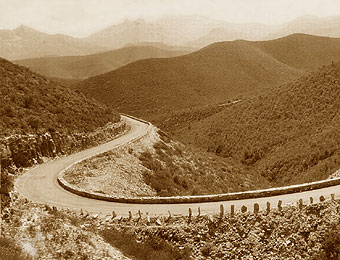
A wonder of roadway engineering for the time, the old Mexico Highway 40 provided two paved lanes that stitched together existing roads with new sections -- many segments of which required substantial road-engineering skills to construct.
Federal Highway 40 created a continuous paved path across north - central Mexico, and the segment connecting Sinaloa State with Durango State was the first reliable and widely used road between Mazatlan and Durango. For the first time in Mexican history, travel between the Gulf Coast and the Pacific was possible for normal people in timeframes less than those measured in weeks!
But the history of ground transport was moving quickly in the mid-20th Century, and booming late 50's and early 60's North America needed more than 1940s roads could provide. Two lanes -- especially ones with lots of curves! -- didn't begin to address the needs of increasingly auto and truck-dependent economies.
If this sounds primitive, remember that things were not that much different in the United States -- the interstate road system in the USA was only a plan when announced in 1956 as a response to the same capacity issues. Even in the United States, many communities -- located in vastly less challenging terrain than the Sierra Madre Occidental mountains -- waited decades to be connected to the emerging interstate highway system.
The re-building of Mexican Highway 40 has similarly taken decades, but true restricted access multi-lane segments were completed long ago between Durango, Monterrey and Reynosa -- Mexican restricted access highways that enabled the more efficient northbound flow of products and people.
However, the dream had always been to link the Gulf Coast to the Pacific and thereby enable efficient trans-continental traffic that would benefit the economies of all of the communities along its route.
The Sierra Madre Occidental mountains that separate Durango from Mazatlan posed unique challenges, and our segment of the highway was the last major part of Highway 40 to be re-built.
Not only are the Sierra Madre between Mazatlan and Durango some of the higher mountains in Mexico, but they are very steep, creating topography that is unusually jagged and that requires tremendous bridge-building and tunneling skills to even begin to plan for an efficient restricted access roadway design that traverses a direct route.
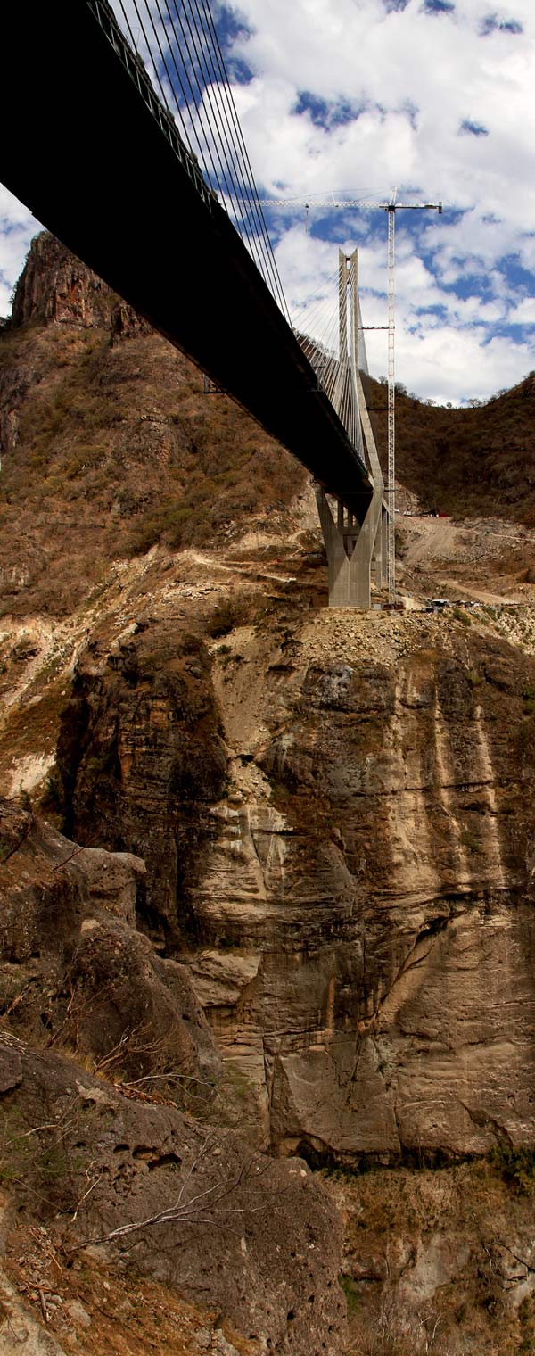
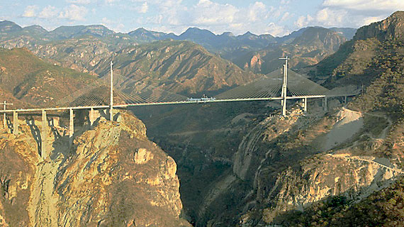
Adding to the general engineering challenges posed by this spectacularly rugged landscape, the Baluarte River slices a deep gorge through the middle of the route that marks the border between Durango and Sinaloa States and which would require unprecedented engineering solutions to span.
No feat of engineering along the new Mazatlan / Durango highway -- not even the nearly two mile long El Sinaloense, the longest of the tunnels -- surpasses that of the Baluarte Bridge, which spans the Baluarte River that marks the border between Sinaloa and Durango States.
With a vertical clearance of nearly 1,300 feet from the riverbed, this over 3,600 foot long suspension bridge is the highest in the world, and one of the longest as well.
The cost of the Baluarte Bridge alone -- estimated at over 150 million dollars over a four year construction schedule -- is indicative of the scale of the entire Highway 40D construction project, which totaled over 2.2 billion dollars.
Including planning and construction work spanning nearly two decades and three Mexican presidencies, the re-engineering of the Mazatlan - Durango highway is arguably the single largest public works project ever completed in Mexico.
Video of the Baluarte Bridge on the Mazatlan - Durango Mexican Federal Highway 40D
The plan for re-building the Mazatlan - Durango corridor was born nearly two decades ago in the Mexico City offices of the Secretary of Communications and Transportation (SCT), the agency which is responsible for Federal highways throughout Mexico.
The sheer materials requirements were enormous -- the new sections and upgrades to existing roadbed required 130,000 tons of steel and enough concrete to build 20 Olympic stadiums. The logistic challenges of transporting this amount of material in such rugged terrain was as daunting as the size of the loads themselves.
The human logistics of the project at times resembled the feats of ancient Egyptian pyramid building: at one point there were 1,200 workers living in a temporary construction community built in the shadow of the emerging Baluarte Bridge.
The outcome of these efforts completely transforms the topography of travel between Mazatlan to Durango and points east -- the mileage has been reduced from over 180 miles to 140 miles, and the expected drive time anywhere from 6-8 hours (or more, especially in Winter...) to well under 3 hours.
Mazatlan actually receives double benefit from the opening of the new Mazatlan - Durango highway.
Not only has it become better connected to markets in the Durango / Torreon / Saltillo / Monterey / Reynosa - Brownsville corridor but -- because 40D intersects with other Federal highways at Durango -- it is now linked to the Durango / Zacatecas / San Luis Potosi / Tampico corridor, and the Port of Tampico on the Gulf Coast.
Mexican Federal Highway 40 / 40D
Now that the new Federal Highway 40D improvements to the formerly difficult Mazatlan - Durango section of Highway 40 are complete, many in Mazatlan have become interested in what lies beyond Durango that they can access by car.
In addition to Mazatlecos looking eastward, the radical re-building of the Durango - Mazatlan corridor makes driving access to Mazatlan from Texas and central parts of the United States much faster -- and less challenging!
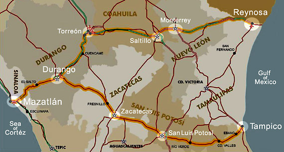
We offer a brief overview of the entire Federal Highway 40 / 40D, all the way from Mazatlan to Reynosa, gateway to McAllen, Texas.
For those considering driving to Mazatlan from Texas, please just reverse this route information.
The distance from Mazatlan to the United States border is approximately 650 miles using Mexican Federal Highway 40 / 40D.
Mazatlán, Sinaloa GPS 23°13'N 106°25'W to Durango, Durango GPS 24°01'N 104°40'W
Approximately 140 miles using Highway 40D toll road segments / About 3 hours drive time
Victoria de Durango is the capital of Durango State and is home to nearly 650,000.
The city lies at over 6,000 feet in elevation and is located on the eastern edge of the Sierra Madre Occidental mountains.
When driving eastbound from Mazatlan towards Durango on Mexican Federal Highway 40 / 40D you are climbing into the Sierra Madre Occidental mountains, the highest and most rugged mountains in northern Mexico.
The highest points that you reach on the highway begin just northeast of Concordia, Sinaloa, and continue until you drop down from the higher mountains southwest of El Salto, Durango State, after which the highway becomes somewhat flatter and straighter.
About 20 miles from Durango the road begins its final descent into the city and it gets somewhat curvier. This is the final extended downhill segment you will experience -- even if you drive all the way to Texas on 40 / 40D -- so drive cautiously, slow down and enjoy the scenery!
The distance for the Mazatlan - Durango segment of Federal Highway 40 / 40D is roughly 140 miles, which makes the route of the new highway 40 miles shorter than the old road when using all of the 40D toll road segments available.
Durango is 140 miles from Mazatlan on the new Highway 40D, and the drive-time should be under 3 hours.
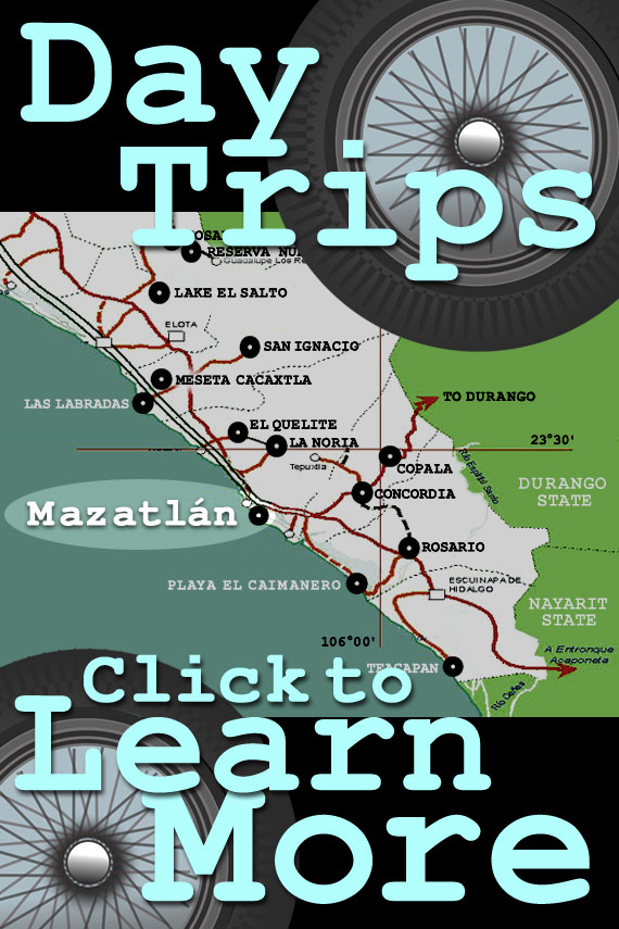
Click here for extensive information about Durango, Durango State -- and day trips to it from Mazatlan!
Mazatlan - Durango route map
from Google Maps
Durango, Durango GPS 24°01'N 104°40'W to Torreón, Coahuila GPS 25°32'N 103°26'W
Approximately 150 miles using Highway 40D toll road segments / About 3 hours drive time
Torreon is a city of nearly 650,000 located at the southwestern border of the state of Coahuila. The city sits on relatively flat terrain at 3,000 feet elevation.
Torreon is roughly 150 miles northeast of Durango, an easy 3 hour drive using the 40D toll road segments that are available for most of the route.
The Durango - Torreon segment of Highway 40 / 40D lies within the central Mexican Plateau, an arid high plains environment that is relatively flat -- which makes for particularly easy driving along this part of the route.
When you reach Torreon you will be about 300 miles from Mazatlan -- in not much more than 6 hours!
Torreón, Coahuila GPS 25°32'N 103°26'W to Saltillo, Coahuila GPS 25°25'N 101°0'W
Approximately 160 miles using Highway 40D toll road segments / About 3 hours drive time
Saltillo is the capital of Coahuila State, and home to nearly 750,000. Located within the Chihuahuan desert at an elevation of over 5,200 feet it can get cold in Saltillo at night in the winter!
Torreon to Saltillo is another segment of Federal Highway 40 / 40D that has been largely upgraded to four lane toll road status, and is as easy to drive as the Durango - Torreon segment that precedes it.
Just 10 miles longer than Durango - Torreon, the 160 miles between Torreon and Saltillo using all the 40D segments can be driven in little more than three hours.
When you reach Saltillo you will be over 450 miles from Mazatlan -- in less than 10 hours driving!
Saltillo, Coahuila GPS 25°25'N 101°0'W to Monterrey, Nuevo León GPS 25°40'N 100°18'W
Approximately 55 miles using Highway 40D toll road / About 1 hour drive time
The Saltillo to Monterrey segment of Highway 40D is short, but scenic.
The 55 mile route skirts the northern edge of the Sierra Madre Oriental mountains that border the southwestern edge of Monterrey.
While not as rugged as the Sierra Madre Occidental that lie between Mazatlan and Durango, these are some of the more spectacular peaks in northeastern Mexico.
There are several opportunities to get on and off Highway 40D and choose the old road -- the Via Libre -- but, if you just stick with the toll road, this segment is just an hours drive.
Monterrey is the capital of Nuevo Leon State, and one of the most important cities in Mexico. With a population of 1.2 million, it is the 9th largest city in Mexico, and one of the wealthiest.
Imagine this: When you get to Monterrey you will be just 11 hours from Mazatlan and very close to the US border!
Monterrey, Nuevo León 25°40'N 100°18'W to Reynosa, Tamaulipas 26°05'N 98°16'W
Approximately 135 miles using Highway 40D toll road segments / About 2.5 hour drive time
The Monterrey to Reynosa segment of Highway 40D is one of the older parts of the highway to be upgraded to four lane / restricted access, and the reasons are as obvious as economics.
The 135 miles of Federal Highway 40D that link Monterrey to Reynosa are the first link in the chain of highways that transport commerce south, and the vital artery for merchandise flowing north.
While the population of Reynosa itself is just a bit over 600,000, the population of the Reynosa - McAllen, Texas, Metropolitan Area is approaching 2 million, making it the third largest metropolitan area along the Mexico / United States border.
By the time you reach Reynosa you're basically at sea level, and most of the drive from Monterrey is flat and straight, making for excellent average speeds -- figure well under 3 hours on the toll road.
When you get to Reynosa you will be all the way to the United States border -- and just 13 hours drive time from Mazatlan!